Monday, November 28, 2016

Day 124-125, Nov. 26-27 Charleston,SC to Yemassee and Savannah GA

For two days this was pretty much the view in my rear view mirror. 
Going from Charleston, SC to Savannah, GA is roughly 120 miles. We decided to knock it out in two days. Day one we rode 68 miles to Yemassee, SC, day two we finished the trip by riding 49 miles to Savannah, GA. Basically, we got on to US-17 and pedaled south-west.  The route can be summed up with the interjection, Arghhhhhhhhhh! US-17 is a heavily used road that runs all the way to Florida. Most of the route was a four lane divided highway with cars whizzing by at 60mph. Since US-17 has no shoulder, riding on it was stressful and more than a little dangerous in spots. Added to that, is the reality that South Carolina drivers have been, by far, the least tolerant of cyclists we have encountered.

We are frequently asked about cars on the road. Aren't we afraid of being run over? or attacked by a road raged driver? Our answer up to now has been that we have little to no problems with motorists. In fact, for every angry honk or shouted comment we have gotten at least a hundred friendly toots, thumbs up and shouts of encouragement. 

Something changed when we got into The Carolinas. I noticed it in North Carolina. People were polite and friendly but not curious about our trip. We were rarely asked what we were doing and drivers went by without comment. No big deal. It just felt odd after being so warmly greeted by motorists in other states, but I never sensed hostility. Drivers still gave us a lot of room and the condition of the roads made riding in NC a true pleasure. Oddly, that changed once we entered SC. Drivers laid on their horns and yelled out their windows even on empty roads where we presented no delay. On the busier roads, we had to "take the lane", riding in the middle of the right lane, or motorists would pass us without slowing and leaving only inches to spare. It was truly scary. I lost count of the number of angry honks and shouts to get off of the road, and we cycled through New York City and Newark NJ where a driver's horn is used as a favorite communication device. 

Salt Marshes are important for their bio-diversity as well as a buffer during
storm surges.
Part of the problem is that South Carolina does not have many roads. Much of the coastal areas are covered with marshes and swamps so it is hard to find a tertiary road that is paved and does not dead end in the middle of nowhere. Basically there is US-17 and the interstate. 

The reality of riding a bike is not will you 
fall; it's when will you fall. In our case it 
was 11/26/16 on a sand road. 
With all that said, the folks we met along the way were friendly and the state is truly beautiful. Both John and I were sad to leave Charleston. It is a must-stop if you are in the region. We had a great time and plan to return... in a car next time.

Saturday, November 26, 2016

Day 121-123, Nov 23-25 Charleston, SC rest days.

Ended staying four night in Charleston. We didn't consider that many/most things we wanted to see would be closed on Thanksgiving. Duh.

We didn't get to do our carriage ride; that has been raised to the top of the list for when we get to Savannah, but we did get to do an historical walking tour, tour the Aquarium, tour the Yorktown CV10, and Laffey DD724, see the Market St market, and had a very nice Thanksgiving dinner.

Charleston is a very historic city that takes itself rather seriously. Per the City Market website, "In 1788, Charles Cotesworth Pinckney ceded the land to the City of Charleston for the express use as a public market, and he stipulated that the land must remain in use as a market for perpetuity." Originally this was a meat, fish and vegetable market, and the merchants would throw spoiled bits of flesh and plant onto the street to dispose of them. This ready supply of food was greatly appreciated by the local buzzard population, which thrived. Charlestonians at first tried to get rid of the birds, but once they realized how much they needed the clean up crew, they relented. The birds were renamed Charleston Eagles because surely buzzards was too coarse a term. The statues that commemorate these avians definitely look like eagles.


The historic district of Charleston is bounded on either side by the Ashley and the Cooper rivers. I have heard that Charlestonians all know that the Ashley and Cooper Rivers meet at Charleston to form the Atlantic Ocean. Yep, inflated sense of importance.

We really enjoyed our walking tour; we would do it again, plus many of the other walking tours available. Two things we saw: Round Church, a nondenominational church on Meeting St. It is the umpteenth church built on this site. The first was built round because folk lore says that the devil hides in corners, no corners, the devil can't trap you. The original church was open to all. If you had seven like-minded people, you could book the church for your religious service or meeting. Jews were allowed, but not Roman Catholics who were not popular in King Charles' England.
The church has a grave yard. There is no source for stone in and around Charleston. Head stones were originally wood. They would be replaced, maybe many years later with stone. The info on the stone might not be totally accurate, but it was the best that the later family could remember.


Round Church grave yard. Round Church to the right.

We also walked around some of the old neighborhoods of Charleston. Beautiful stuff.


 French quarter, obviously.


Live oaks in Washington Square. Immense trees over 100 years old.

 For me, the best tour we took was that of the USS Laffey DD724. When I was in the Navy, I served on board two ships, both of them Sumner class destroyers, The USS Zellars DD777 for about ten months, and the Laffey for a two week training cruise. The ships were identical. Only one Sumner class DD still exists, Laffey. Visiting her was like taking a walk back into time.


You can see that there are two gun mounts (turrets) on the bow. Behind and above them is the bridge. Behind and above the bridge is a little gray box with a funny looking radar antenna. That is the gunfire control director; that was my battle station.


Four men manned the director, my station was in the center behind the milky (should be clear) optics. Scuttlebutt was that we had a 30 second life expectancy in combat, either the opposing ship's fire control men would die, or we would. Fortunately I never had the opportunity to test that assumption.


Better view of the Mk 25 tracking fire control radar.


Captain's seat on the bridge. NO ONE would EVER sit there except the Captain. Felt rather comfy.

Today we rode 68 miles from Charleston to Yemassee, SC, but I am too tired to talk about it right now. Tomorrow.

Wednesday, November 23, 2016

Day 120, Nov 22 Moncks Corner, SC to Charleston, SC


I have friends that say, "I've been getting up at 5 in the morning for 30 yrs, and I can't sleep in." Yah, not so much. I have acclimated to sleeping in just fine. After many years of getting up long before dawn, I might wake up, but I immediately roll over and go back to sleep. For that reason, plus the fact that it was 31 degrees at 7:30, and we only had 34 mile to go, we didn't leave for Charleston until eleven. 

The trip into Charleston was a departure from the last several days of riding in a number of ways. Up until now, we've been traveling through the rural parts of North and South Carolina. Our view has been small farms and damage from Hurricane Matthew. Predominately, the houses have been double wide trailers and manufactured homes. Many were well kept up, but a lot of them looked like the folks in them were struggling to make end meet. Most of the businesses were boarded up. Like a lot of the countryside we have ridden through, manufacturing/industry has left and there are no jobs for the people left behind. 

Also, the weather, while sunny and cloudless has been cold. Waking up to temperatures in the 30's has been commonplace. Knee and arm warmers have been a day long necessity since the temperatures have been peaking in the high 50's. For two days, palm trees began to appear, but they were small and most had drip irrigation. But the biggest change was traffic. Before leaving Moncks Corner, we were able to ride on roads that had very little traffic. 

All that changed as soon as we pulled away from Moncks Corner. Suddenly, we were in suburbia. Housing developments with names like Montgomery Plantation. Where the houses were spacious and had attached garages. It was like someone drew a line that announced the change. 


Spanish moss is actually an air plant, it doesn't hurt the tree and people down
here seem to be fond of it. I think it looks creepy. Yuck.
With the nicer housing came a lot of traffic. We scoured the map but were left with no choice but US-52. Going into Moncks Corner US-52 was a great road that only became congested and we neared town, but was chock-a-block full all the way to Charleston. John and I are accustom to city riding but this was like being on a freeway. It was a long 32 miles. 


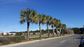
Most surprising to me was the shift in climate. It wasn't just the warmer weather, the vegetation changed. Where palms were small and not very robust, now they were huge trees with glossy leaves. Everything was greener and more lush. Even the Spanish Moss looked greenish instead of a creepy dead brown. The change in climate/growing zones has to switch somewhere, but it seems abrupt when traveling at 12mph. 

Tomorrow were beginning our day with a two hour walking tour followed by a carriage ride. We plan to have an early turkey dinner at the restaurant next to our hotel, followed by football for John and a walk on the beach for me.

I hope all are well and have a great Thanksgiving.


Monday, November 21, 2016

Day 119, Nov 21. Lake City to Moncks Corner, SC

A lot of today's route was on U.S. 52. I was concerned the traffic would be so heavy as to make this a 'ride for survival' kind of day. Not so much. Route 52, while two lanes each way, with a median and no shoulder, proved to be a very lightly traveled road, with barely perceptible grades. Flat country is where a tandem flies, we averaged 14 mph for the 55 miles today. Not bad for a 70 pound bike and a 60 (500?) pound trailer. Route 52 was so pleasant that we ignored Google maps every attempt to shunt us onto less traveled, and longer, side roads. Today reminded me of the longest day on our ride from Seattle to Washington, DC, where the short cue-sheet read something like:

"mile 5, turn right on U.S. 12
mile 112, turn left off route 12 into camp site."

We were on route 52 all day.


Not much traffic early on, and very flat all day.


Lots of water today; lots of swamps too.


The C&O tracks followed us all day.

All good things must come to an end. Traffic got a bit heavier as we got closer to Moncks Crossing, but still not objectionable. Then, 1.2 miles from our turn off for our motel, U.S. Alt 17 joined our road, easily doubling the traffic without adding a lane. NOW we were in survival mode with Margaret constantly watching her mirror, while I split my attention evenly between the road ahead and my mirror. To add to the fun, this short section of highway also went over the Copper River/Tail Race Canal on a high, steep bridge. There is nothing like taking up one lane of a very busy two lane highway while doing 6 mph.

We are experienced cyclists, and we made it through. Then after a shower, we found the Tail Race Tavern and filled up.


Beer candied bacon

For anyone who may be curious, beer candied bacon is "Thick Cut Hardwood Smoked Bacon candied in Beer, Brown Sugar & Fresh Rosemary topped with Scallion." Oh yeah.

Tomorrow we ride 35 miles to Charleston, SC. We will be staying three nights.

Friday, November 18, 2016

Day 118, Nov 20. Mullins, SC to Lake City, SC

Riding on US76, a 55mph divided highway, is not my
idea of a fun time.
For the most part, we have used Google Bike Maps to route ourselves from city to city. Once Google has generated a map we look it over to see if it makes sense to us. Frequently, John will go on Google Earth to check out roads that we fear may not be a good choice.

We try to avoid highways and other heavily traveled roads on one end of the spectrum and unpaved roads on the other, but it is not always possible. Currently, we have the added complication of roads and bridges damaged by Hurricane Mathew.


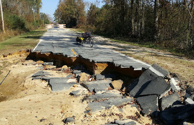
Often we can get around road work. ...not so much today.
Today we got a bit of everything a route can throw at you. Highway 76 was unavoidable and unpleasant. Having cars and semi-trucks speed past us at 55+mph is at best an adrenaline producing event. Lucky, it was only 5 miles and most of the drivers gave us plenty on room.

Often we are able to ride or walk our bike around construction, not today. It was obvious from the start, that we were not getting around this one. Looking at the map, we found a way around, it would add a few miles but looked do-able, so we headed out.
Over the edge was a 10 foot drop to the water below. 
Without the ability to levitate, we had to reroute.

Our next challenge came in the form of  a five mile long unpaved road. Many unpaved roads are crushed rock that is pack down. Though it slows us down, they do not pose much of a problem. Not in the Carolinas. In general, roads in the Carolinas have been great. Even lightly traveled rural roads have been beautifully paved. The unpaved roads have been a different story. The soil here is very sandy, so the unpaved roads are a combination of packed sand, gravel and tire swallowing sand traps. It was a no go.

With only 14 miles to go, we made what we hoped would be our final reroute, crossed our fingers and headed in. Our 43 mile ride ended up being 50 miles. Tomorrow we go to Moncks Corner. One day closer to Charleston.


Day 116-117, Nov 18-19. Lumberton, NC to Mullins, SC, and a rest day

Yet another beautiful day to ride. Almost had to take my knee warmers off, but they stay on until it reaches 70F, and it only got to 69F today.

The devastation caused by Matthew still hits you at every turn. We have stopped remarking on downed trees. Only the most spectacular now deserves mention. I would bet that we have ridden past well over 1,000 downed trees, and remember that these are the ones still left after over a month's worth of cleanup.


Lumberton today.

 
Lumberton, five of seven large trees gone on N Elm St.

We also continue to see many 'road closed' signs. Again, we had one on our route today. This time, we did not luck out.


There are other signs of the losses folks have suffered. There are piles of mattresses on the side of the road, as well as furniture and broken pieces of 'stuff.' All these are things that were soaked by flood waters, and must be discarded. You also see fences that are choked with grasses and brush that the flood waters pushed against and through them. Some fences couldn't take the pressure, and were pushed down flat. Many buildings have blue plastic tarps covering their damaged roofs. And I keep reminding myself that they have had five weeks to clean up the mess. How much worse was it on day one?

These are some tough people.

On a more mundane note, in my last post, I pictured a field that I speculated might be harvested cotton. We passed one today that appears to be awaiting harvest.


The white fluffs felt just like cotton balls, but they had little lumps (seeds) in them, and were surrounded by some pretty stiff husks. Harvesting cotton must have been pretty tough on the hands before mechanization.


We crossed into South Carolina today, the fourteenth state we have ridden in on our trip.

Yes, the bike made it too.


Tomorrow is a rest day, laundry, veg out, the standard things. A few days ago, 11/19 was supposed to have heavy rains, and we thought we had timed this perfectly. Now the threat of rain has gone away, so our rest day should be sunny and in the low 70's. Not so bad.

Thursday, November 17, 2016

Day 115, Nov 17. Fayetteville, NC to Lumberton, NC


Image result for lumberton nc hurricane matthew pictures
The road into Lumberton just one month ago.
Since the ride into Lumberton was only 37 nearly flat miles, we laid in bed until 8 and ate a leisurely breakfast. The weather was beautiful - warmer than it has been in a couple weeks and sunny. The road seemed to fly by. We averaged 13mph- quite fast for us. We generally are thrilled to get an 11mph average.
Clean up underway.


We are riding into the areas most effected by Hurricane Mathew. In fact, a gentleman we met while having lunch, said Lumberton was one of the hardest hit cities in North Carolina. His business was under 10 feet of water; he lost a lot of his equipment and had to relocate.

We passed lots of roads under repair and many downed trees, most fields and yards looked like water swept through them, and trash is still littering the roadside, but other than that, the area looked surprisingly unscathed. Tomorrow we go through downtown Lumberton and there may be more damage there.


Cape Fear River
Before and after shots of the Cape Fear River.


Downed trees littered the sides of the road.


Google gave us a dirt road to add a 
little variety to the trip.
Cape Fear River looking peaceful.


Wednesday, November 16, 2016

Day 114, Nov 16. Smithfield, NC to Fayetteville, NC

Another fantastic day to ride. Our arm warmers came off in the first 20 minutes, and it was sunny and in the 60's all day.

We are now in the area of North Carolina that was effected by Matthew. Many downed trees are still visible, and there are still lots of 'road closed' signs. One of these was on our route, but we took a chance and continued. We lucked out.


Most of the day, the terrain gently rolled. We were almost exclusively on tertiary roads, so most of the day we saw this:


The dominant conifer in these parts is the Loblolly Pine. The tree grows rapidly, more 24 inches a year, and is planted for pulp wood, structural wood, and as a shade tree. The needles are 8 inches long, so branches of young trees can look rather furry. The tree will grow to almost 100 feet in height.


We always try to notice and understand the crops we pass while riding. Mostly we have been seeing beans and corn, with the occasional tomato and squash. Today, however, we began to notice evidence of a new crop. Dry sticks with some white fluffy bits scattered on the ground.


Harvested cotton, maybe?

We arrived in Fayetteville around 2:30 PM, 04:16:28 of bike time and 53.7 miles today.


Tomorrow we ride 38 miles to Lumberton, and our last night in North Carolina.

Tuesday, November 15, 2016

Day 113, Nov 15.Cary, NC to Smithfield, NC


We had a lovely visit with John's sister, Alicia and brother-in-law, Gordon, but all good things must come to an end, and cold weather is upon us, so we headed out to Smithfield today. The trip was 37 miles long, in sunny 60 degree weather. It was a pleasant and nondescript day. Pleasant roads with nothing to complain about or expound upon.

Smithfield, NC is the county seat of Johnston County. There is an Outlet Mall if we wanted to get a bunch of stuff we don't need and do not have room for. Other than that, there is not much to say. Tomorrow we head to Fayetteville, NC. Ultimately, our short term goal is Charleston, SC, and then Savannah, Georgia. A total of 360 miles by Thanksgiving.

Sunday, November 13, 2016

Day 106-111, Nov 9-13. Rest days in Cary, NC

We have been having a wonderful time staying with my sister and brother in law in Cary. Mostly we have been goofing off, but some "important" stuff has been happening:

Alicia and Gordon took us to the North Carolina Museum of Art for an exhibit of Art Deco cars from the 1930s and 40s.


1938 Talbot-Lago T-150C-SS Teardrop


1936 Peugeot 402 Darl'mat Coupe


1941 Indian Model 441


1938 Delahaye 135M Roadster


Only one ever built. It was destroyed; this is a hand built, working reproduction.

We took many more pictures. Amazing examples of art triumphing over function.


We also went to Wilmington, NC to see the battleship. USS North Carolina BB-55. What a magnificent dinosaur. We crawled all over her. Margaret tells me that her cell phone counted 5,000 steps during the visit.


 Looking forward from the bridge


 On the bow, looking back at the bridge.

https://en.wikipedia.org/wiki/USS_North_Carolina_(BB-55)

One of the reasons we have delayed our departure for points south, is to attend Friendsgiving. This is an annual Thanksgiving style get together, hosted by my sister's son, David. He and his wife, Bailey, are very active in local sports clubs, so they have a lot of friends; about 40 or 50 people were there. David provides turkey and ham, and everyone else brings a dish. Margaret and I were looking at celebrating Thanksgiving on the road in some strange town. This was an opportunity we could not pass up.

We also had some maintenance to take care of. The hoses from our Camalbak bladders have become stiff from UV damage, so we decided to go to REI and replace them. Surprise, two weeks ago, Camalbak began replacing the hoses with slightly larger diameter ones. They claim 20% increase in quantity of water per sip, but now our tube connectors are too small. Surprise, when we went back to REI to get new connectors, they had none. They expected them in about two weeks. We decided to replace the bladders at REI, and went to Lowe's to get a connector to splice two tubes together as well as some alligator clips to fashion into tubing clips, as our old clips were now also too small. A simple job made complex, but completed none the less.

We plan to leave Cary on Tuesday, 11/15. We had originally planned to leave Monday, but a 70% chance of rain has dissuaded us.