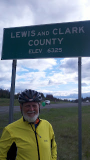
62 miles. That seemed like a vacation day but, of course there was a catch; we were climbing to the top of the continental divide - 6,356 feet. We gained somewhere around 2,500 feet of altitude during that climb! Before we could cross the divide we would have to climb 11 miles uphill. Not only uphill, but
really uphill at the end. According the the Map My Ride elevation charts, the hill would start gently and rise to a 6% grade. (trust me, that's really steep). We were
a little a lot worried. Our tandem does not climb well. It is simple science, heavy objects take more energy to move uphill and less to go downhill. Gravity would do the downhill part, we would have to do the uphill. As it turned out, the hill was
really long but not as steep as reported. We put the bike in its lowest gears and slowly spun our way up to the top.

I thought there would be a viewing spot on the continental divide. Nope, just a sign that reads:
Lewis and Clark County ELEV 6325.
To be fair, there was a viewing spot down a rutted dirt road inside a state park but it was cold and really windy up there. Really cold. We both had on double layers, coats and gloves and we were freezing. We decided to take some pictures and head down the hill.
 |
| The view descending the Rockies |
And head down we did. Fast. Scary fast. John had to use the breaks so much they heated up and discolored! The grade was steep and the switchbacks sharp, but the view was beautiful and it was nice to let gravity do the work for a change. As we got to the bottom of the mountain, we were able to warm up a bit as the air temperature was a good 20 degrees higher. The rest of the day went by uneventfully, and we were able to sleep inside Broadwater High School that night.
 I thought there would be a viewing spot on the continental divide. Nope, just a sign that reads: Lewis and Clark County ELEV 6325.


1 comment:
Great Pics! You guys have really done a great job! The recent trials moved you from "looking like bikers" to now you're "definitely bikers". I am amazed at the feats you two have accomplished so far. Keep up the hard work!
Post a Comment